CoastSense's technology monitors waves, currents, tides and weather and delivers remote, autonomous and continuous data collection to organisations across the world. Our services help improve efficiency and so save money and lower carbon emissions.

Understand more

Multi-parameter timeseries data, some covering many square kilometres, helps you observe the changes experienced by your assets as well as the forcings which drive them.

Data product type Resolution Update period Accuracy Formats
Intertidal DEM 3m grid Tide cycle (2wk) Within 10cm of Lidar (typ, depends on conditions) GeoTiff
Sub-tidal DEM 80m grid typ Daily 10% of depth GeoTiff & NetCDF
Surface current grids 80m grid typ 30min (typ) 10% magnitude & direction NetCDF
Virtual buoy wave statistics Up to 10 virtual buoys placed at any grid point 30min (typ) 10% CSV
Tidal elevations Depends on source 30min (typ depends on source) Depends on source NetCDF
Local meteorological sensors (Windspeed & direction, barometric pressure, humidity, temperature) Various 10min Various CSV
Optical images 4096x2160 10min, 30fps N/A Jpg & mp4

Nearshore survey data

We install, operate and maintain innovative shore-based sensor platforms, producing data in near-real time. Ideal for monitoring of extensive, remote coastal areas, especially dynamic intertidal areas which are traditionally difficult and expensive to survey.

We then apply our cutting-edge algorithms to deliver a stream of data direct to users through our download portal, multi-parameter viewer and transfer to government archives. This gives you unprecedented situational awareness allowing you to make more effective, data-based and budget-saving management decisions.

CoastSense’s radar-based technology has been developed in partnership with world-leading scientists at the National Oceanography Centre and the University of Liverpool. We continue to work with our academic partners to provide cutting-edge data products and continually update our algorithms through on-going R&D, striving to provide the best possible nearshore observation technology.

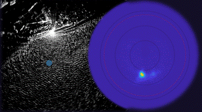
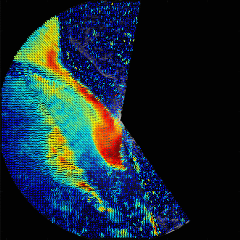
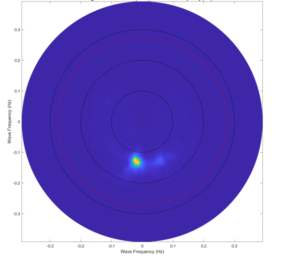
Our regular hydrographic surveys in complex and dynamic nearshore coastal areas use radar, video camera and other sensor technologies to derive topographic, bathymetric and hydrodynamic (wave & current) data in shallow coastal waters. Data is collected from the fixed remote sensor platforms, enabling regular automated repeat-surveys with a high temporal resolution. Large and inaccessible areas can be observed safely, using shore-based sensor platforms.

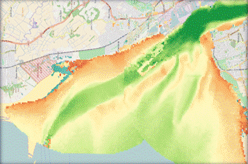
CoastSense data increases your situational awareness of challenging operational environments and provide better understanding of sediment migration and trends of erosion and accretion. The result is better-informed planning and decision-making for maintenance operations, nearshore dredging and coastal defence construction.

“CoastSense understand the importance of evidence including beach draw down, channel movements and beach dynamics.”

Carl Green, Head of Engineering Services, Wyre Council

Intertidal & subtidal topographical monitoring

Is your stretch of coast eroding or are you seeing unexpected changes in the local sedimentary regime? CoastSense offers you a cost-effective way to monitor both dynamic intertidal and subtidal zones using a shore-based sensor.
CoastSense data subscription service delivers a series of topographical DEMs straight to you. Our platforms build comprehensive topographical maps of the intertidal and subtidal zones with an effective range of 4-5km.

CoastSense rapidly accelerates understanding of coastal processes, even in challenging operational environments. Data collection and processing is autonomous and continues 24/7 so that you never miss a storm, allowing clear observation of erosion, accretion and sediment migration.
Near-real time data enables rapid responses to unexpected changes in weather, morphology or damage caused by storms – particularly important in flood and coastal erosion risk management.

  • Cost-effective monitoring allowing greater spatial and temporal densities of data to be collected over large areas.
  • 26 topographical surveys per year tell the complete story of coastal change.
  • Regular surveys of every spring-neap tidal cycle aswell as pre- and post-storm impact assessment and subsequent change or recovery.
  • Vertical accuracy comparable to Airborne LiDAR.
  • Volumetric sediment displacement assessment.
  • Greater situational awareness during survey campaigns, allowing MBES surveys or LiDAR flights to be targeted more cost-effectively at problem areas.

Surface current monitoring

When it’s crucial to understand what’s driving sediment migration around your coastal assets (whether a navigation channel, seawall, beach or dredging site); CoastSense gives you near-real time current directions and magnitudes over a large area, supporting your sediment management decisions.
Our shore-based radar system continuously images up to 6km range and produces a high resolution vector map describing surface current directions and velocities. Updated every 30 minutes, in combination with other data products, gives you unprecedented situational awareness.

  • Understand and record hydrodynamic regimes to make more cost-effective coastal management decisions.
  • CoastSense uses shore-based radar sensors to image wave fields within line-of-sight and typically 4-6km range. It analyses the behaviour of waves to infer the magnitude and direction of the current.
  • You can monitor many data points over a wide area for comparable cost to an in-situ bed-mounted sensor.
  • Measurements compare well with existing technology, even in shallower waters.Gain deeper understanding of local coastal processes and optimise dredging and beach nourishment activities

Wave field monitoring

The nearest wave buoy can be tens of kilometres offshore but with CoastSense, you can place up to ten virtual buoys, within the observed area capturing directional wave spectra, allowing you to construct and validate conceptual and numerical models.

Near-real time observations enable rapid operational decisions during, and in response to, storms. The radar captures images of the wave field every few seconds and our algorithms convert a cube of space-time data into the wavenumber-frequency domain, allowing a directional wave spectrum to be derived and updated rapidly.

CoastSense wave monitoring allows greater insight into local hydrodynamic regimes and allows you to record wave directions, periods and wavelengths continuously in near-real time.

  • Remote, autonomous and continuous data collection without expensive telemetry systems.
  • Multiple virtual buoys offer great flexibility in data collections campaigns.
  • Ideal for monitoring exposed ports and harbours where knowledge of local hydrodynamics is critical to operations.
  • Understand and record hydrodynamic regimes to make more cost-effective coastal management decisions.
  • Supplementary radar image data allows you to observe detailed patterns of wave field diffraction and refraction.
  • Build better models to make more accurate predictions.
  • Gain deeper understanding of local coastal processes.
  • Optimise dredging and beach nourishment activities by working with natural processes that are being continuously monitored.
  • Reduce cost and risk of data collection by having sensors on land.